

Our team has worked on polar ecology, remote sensing, and meltwater impacts for decades. Starting in 2025, we are focusing on the biogeochemical and ecological impacts of icebergs in coastal Greenland habitats.
Photo by Jack Pan

Coastal Greenland Ecosystem
Greenland extends from 60° to 83°N, with 80% of its landmass covered by the Greenland Ice Sheet. Glacial inputs, both from icebergs and meltwater, along coastal Greenland are a source of iron and other nutrients that support the base of the food web, phytoplankton.
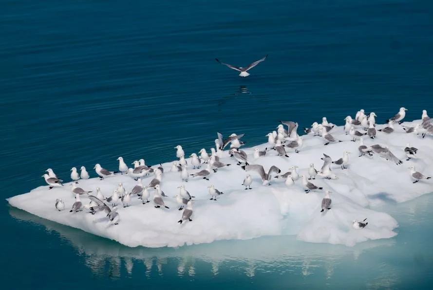
Fjords and bays in western Greenland and the Canadian High Arctic have been identified as hotspots of productivity, with large aggregations of zooplankton, seals and feeding whales, supporting local fisheries. Icebergs also serve as important foraging and resting locations for many species of seabird and marine mammal.
CC photo by Velkiira @ Flickr
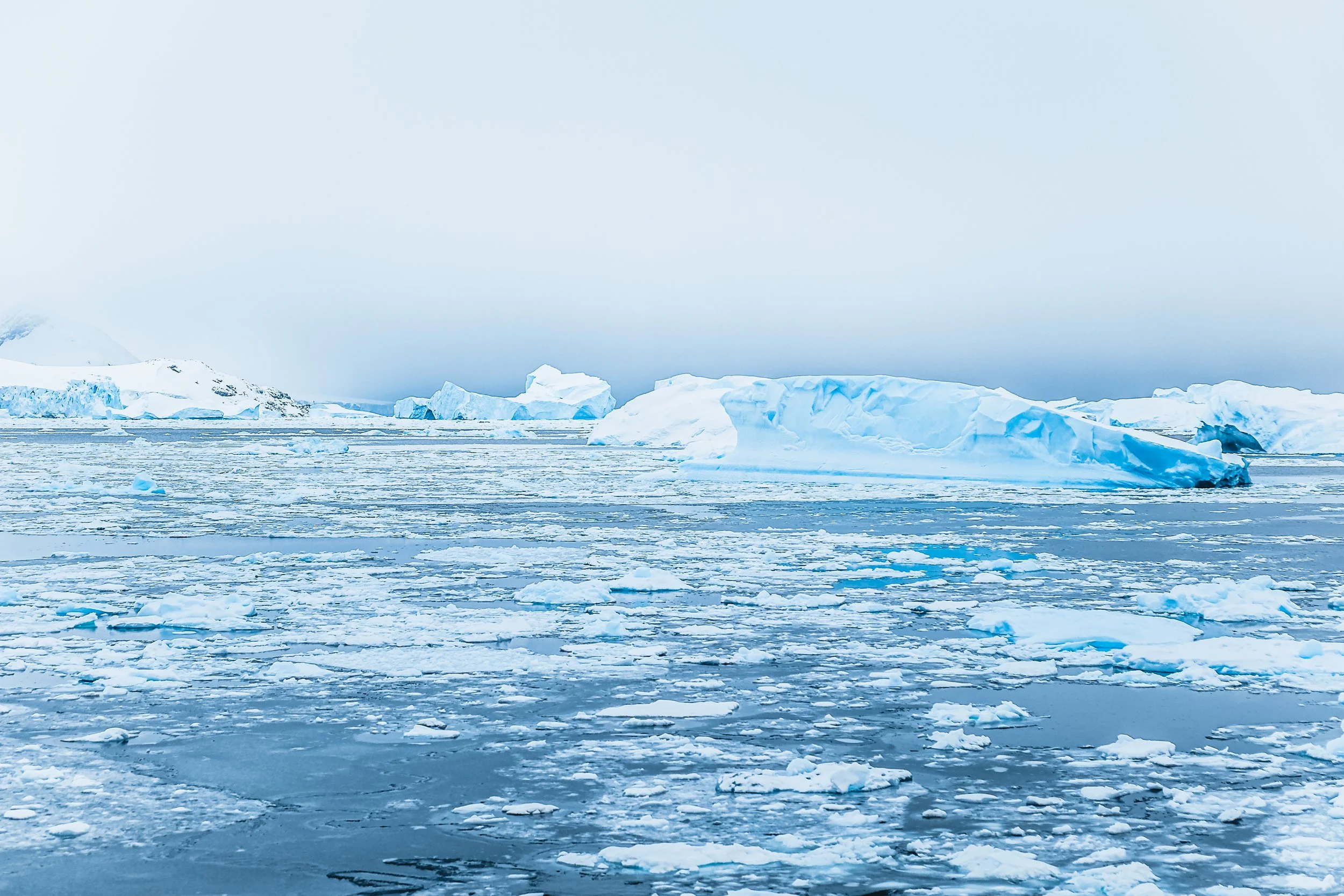
The air and ocean around Greenland are warming, resulting in retreating glaciers and more iceberg calving (i.e., breakaway ice from glaciers) and freshwater input from melting into the Coastal Greenland Ecosystem. Iceberg calving has increased dramatically over the last two decades and accounts for half of the mass loss of the Greenland Ice Sheet.
Icebergs & Meltwater
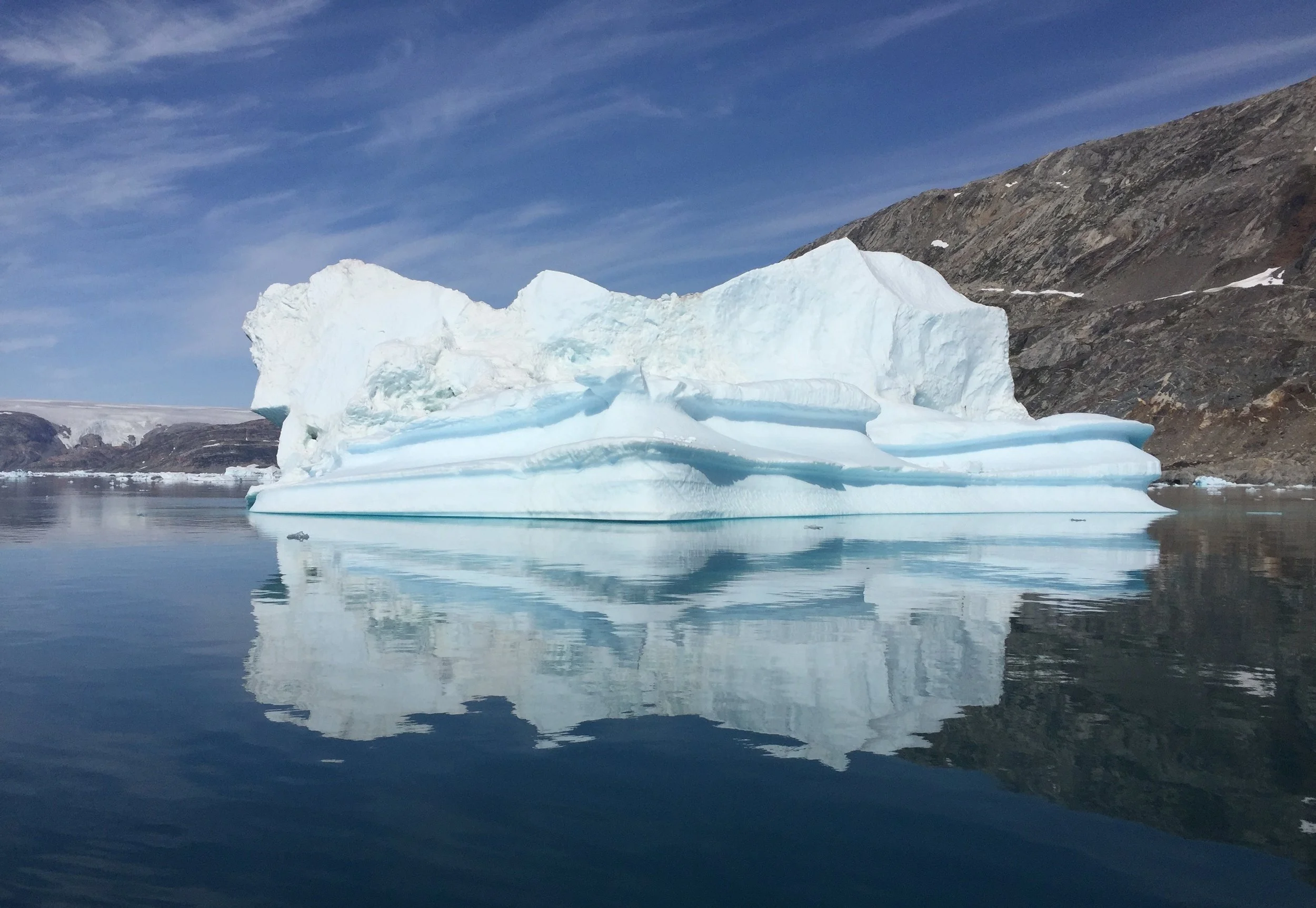
In addition to their contribution to global sea level rise, the increase of icebergs extends the influence of glacial melting away from the coast. As icebergs float offshore and along currents, they continually melt and release freshwater and glacial nutrients into the marine ecosystem. As warming in this ecosystem continues, icebergs will become more abundant in this ecosystem, expanding the reach of melting glacial ice across this system.
Our previous research found that icebergs affect the surrounding water properties, and have detected meltwater as far away as 19 km from an iceberg and that meltwater persisted for at least 10 days.

The usual methods to study meltwater are based on direct (in situ) ocean measurements of seawater samples. Meltwater is typically colder, less salty, and more turbid (i.e., less clear from particles in the water) than ambient ocean waters, and salinity measurements are often used as an indicator of meltwater content. However, in situ measurements are challenging and expensive to accomplish in polar locations, they also require complex and expensive laboratory analyses, and are limited in the spatial and temporal extent of sampling.
Remote Sensing

Because meltwater carries fine inorganic particles, it affects the optical properties of the seawater, making it observable from satellite sensors. The use of satellite-derived data (remote-sensing) to assess meltwater in polar environments would reduce costs, increase the spatial and temporal coverage, and expand our ability to understand and monitor meltwater dynamics. Previous work by our team, confirmed this relationship between in situ measurements and satellite data in Antarctic fjords, and that satellite data could be used to better understand the extent of glacial runoff. Based on these observations, we developed a machine learning model for the detection of glacial meltwater using airborne (e.g., PRISM) or satellite (e.g., MODIS-Aqua) measurements of ocean color.
However, the meltwater from the melting of the Greenland Ice Sheet will likely have different optical properties than meltwater in Antarctica and will require a refined or new ocean color model. Therefore, collecting water samples in situ is the main objective of the IceEco project.

Phytoplankton


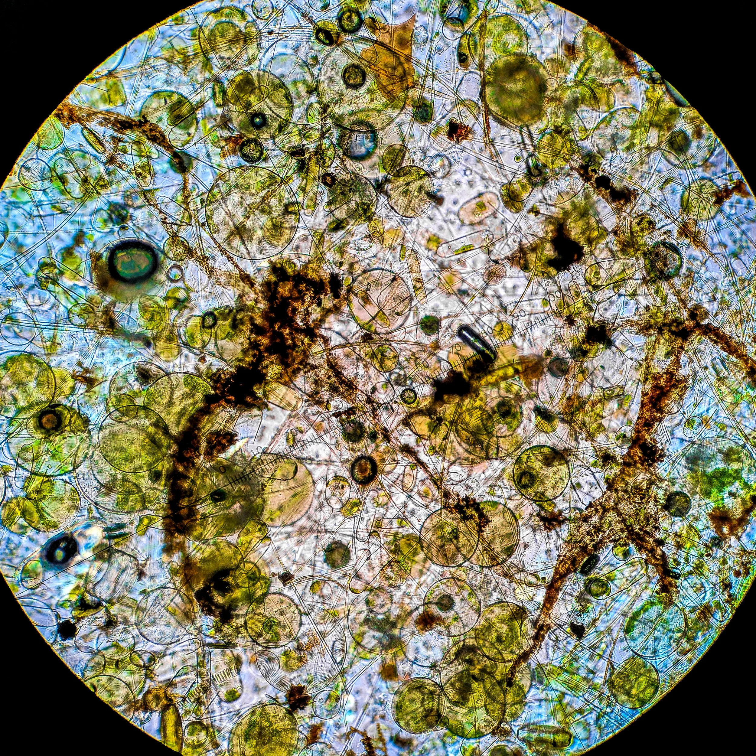


Single celled, photosynthetic algal cells, called phytoplankton, are the base of all marine food webs. There are over 100,000 species, with a variety of sizes, shapes, and nutrient requirements. Within different locations and seasons, the phytoplankton community changes, depending on salinity, temperature, and the amount and type of nutrients available.
IceEco will investigate how increasing icebergs and meltwater affect phytoplankton abundance and community composition in the coastal Greenland ecosystem. This work will also inform how these changes at the base of the food web may affect the structure of the entire coastal ecosystem and result in a better understanding of how climatic variability is altering polar environments.
Our previous research was the first to describe rates of regional primary production within Greenland’s coastal ecosystem. We found that phytoplankton blooms occur earlier in the south and that the presence of sea ice determines bloom initiation. There are also higher rates of primary production in the south, which is heavily influenced by North Atlantic waters.
We also discovered that the biomass of phytoplankton that is advected (horizontally transferred) from the North Atlantic into the Arctic Ocean was 5-50 times higher than the phytoplankton biomass produced in local waters (i.e., in situ). This movement of phytoplankton into these waters is seasonally variable, with minimal contribution during the season with high in situ primary production (maximum in June).
Through our Antarctic research, we found that icebergs alter the ecosystem and drive increased primary production in a ring (up to 2 km) around the iceberg through its meltwater contributions. Due to the increased phytoplankton abundance around these icebergs, they are also prime foraging sites for multiple trophic level organisms, from krill to seabirds.

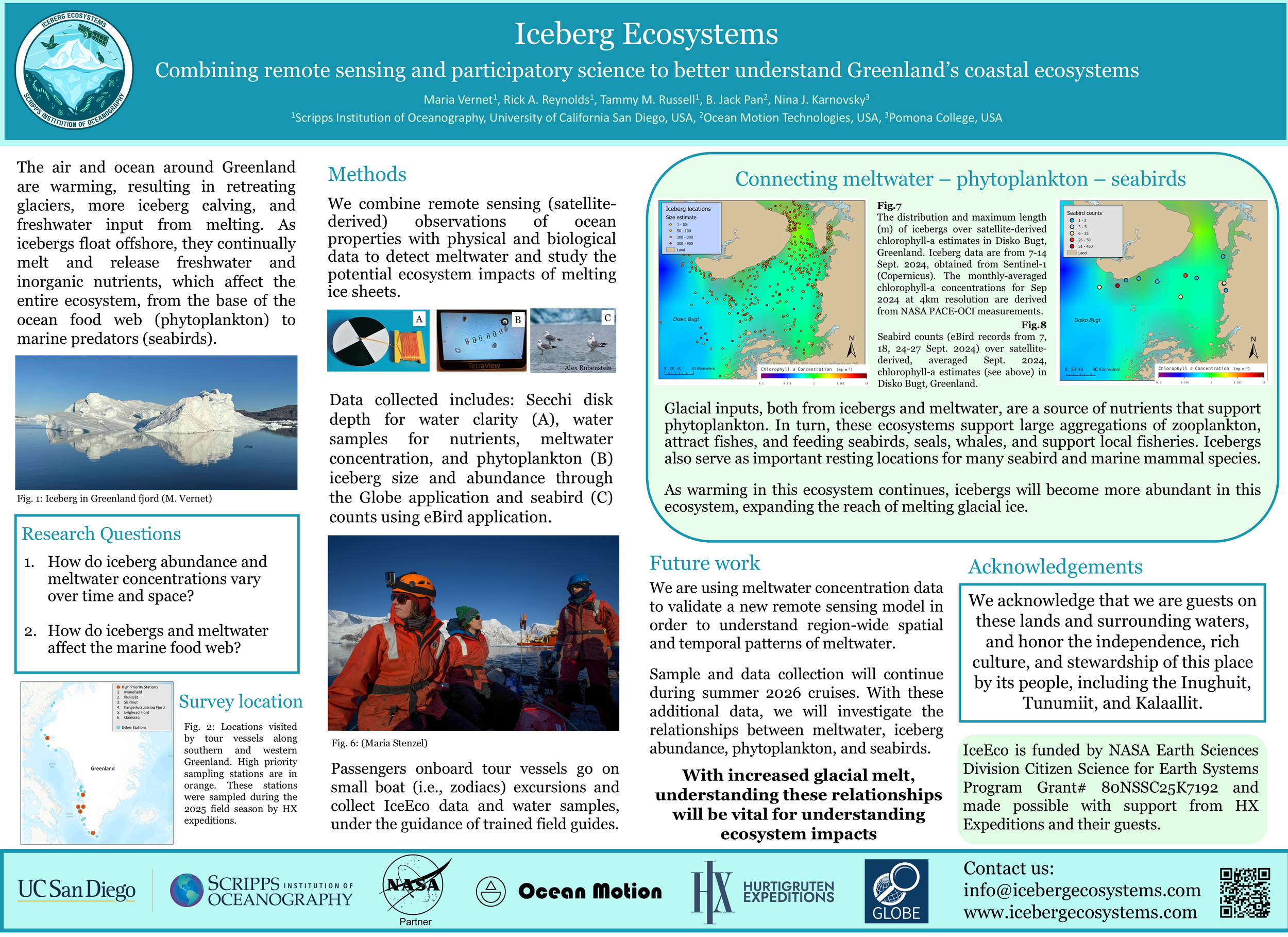
Results
In 2025, IceEco traveled to Nuuk, Greenland to introduce our project and present initial finds based on existing citizen science (eBird) and satellite derived data on chlorophyll-a concentration and iceberg abundance.
Download the full poster here for more information.
Data Products
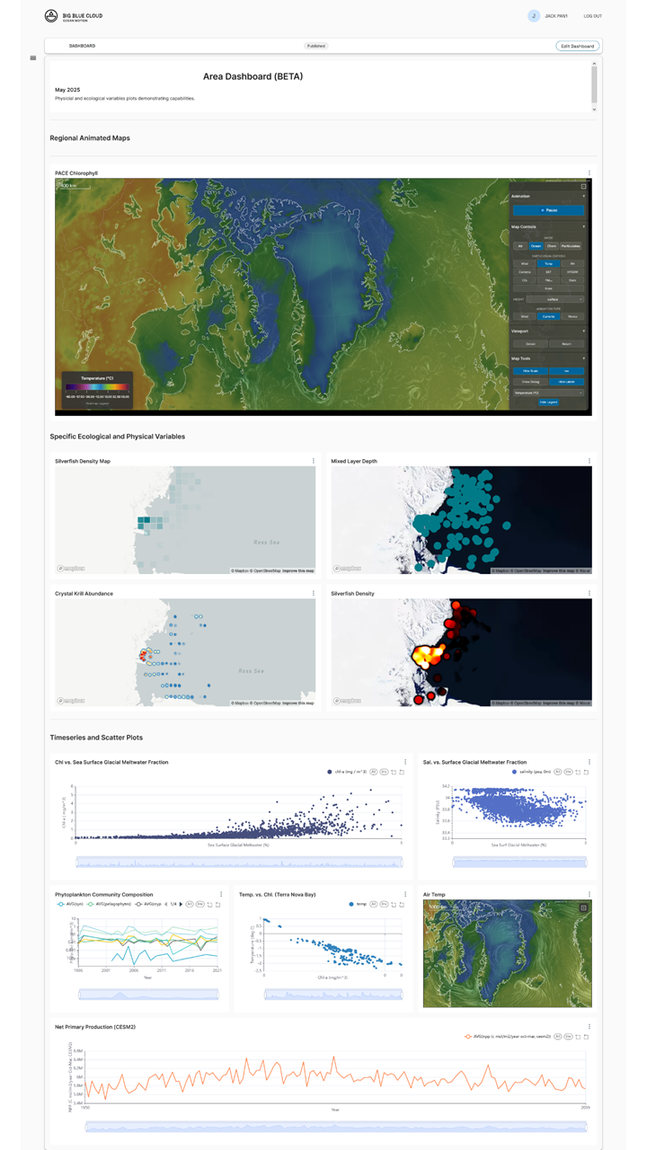
Big Blue Cloud
The Big Blue Cloud, developed by Ocean Motion Technologies (OMT), is a cloud-based data science open platform designed to support the research and management needs of big ocean data. Leveraging cutting-edge data integration and analysis capabilities, the platform aims to facilitate informed decision-making, enhance conservation strategies, and foster collaboration among key stakeholders.
The Big Blue Cloud offers a robust suite of features that ensure comprehensive data management and analysis:
Data Ingestion and Management: Supports a wide range of oceanographic datasets, including satellite remote sensing (e.g., MODIS, PACE, VIIRS), in-situ observations, and model outputs. Data is hosted through a repository and with collaborating partners, providing version control, access management, and data traceability.
Public Data Catalog: Enables researchers to access a variety of public datasets and generate custom data products using intuitive querying tools. This catalog supports international collaboration by allowing users to share data across different organizations.
Advanced Analytics and Visualization: Users can create interactive dashboards and visualizations, integrating datasets across spatial and temporal scales to support conservation decision-making. Dynamic filters and multi-dataset support allow for customized data analysis.
Automated Machine Learning (AutoML): The platform's AutoML capabilities streamline complex analyses, enabling users to uncover insights into ecosystem dynamics. This tool supports the identification of key drivers, facilitating more effective monitoring and insightful environmental intelligence.
Other Arctic Research
Dr. Fiamma Straneo
Collaborative work led by our colleague, Dr. Straneo, described the environmental changes occurring in Greenland and its coastal waters and how those changes will have ripple effects on the ecosystem, fisheries and the people of Greenland. This work described the geographic and climate characteristics that support thriving coastal environments, and how they might change in the future.
